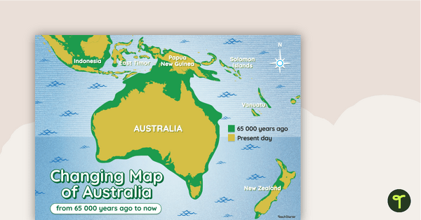
A map showing the changes in Australia's coastline from 65 000 years ago to the present day.
The Changing Face of the Australian Continent
Like all continents on this great rocky planet we call home, the shape of Australia has changed since the arrival of our First Nations peoples over 60 000 years ago.
This map provides a visual representation of the changing face of the Australian continent over the past 65 000 years.
The green areas of the map represent how Australia (and some parts of Asia) looked around 65 000 years ago. The yellow areas represent what these areas look like today.
This classroom poster makes the perfect accompaniment to your Australian History and Geography lessons!
Easily Download and Print This Resource
This resource downloads as a full-colour PDF. Access via the Download button above.


0 Comments
Write a review to help other teachers and parents like yourself. If you'd like to request a change to this resource, or report an error, select the corresponding tab above.