Discover the location of some of the countries neighbouring Australia with this simple cut-and-paste worksheet.
Exploring the Countries Neighbouring Australia
While the continent of Australia is also a single country, it is surrounded by many island nations that we consider to be our neighbours.
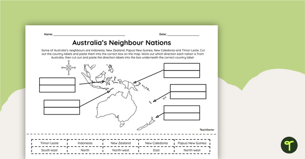
This mapping worksheet has been designed to help students become more familiar with the countries neighbouring Australia: New Zealand, Indonesia, Timor-Leste, Papua New Guinea and New Caledonia.
The worksheet includes a map of Australia and surrounding countries. Students are required to cut out the country labels provided and then paste them into the correct box on the map. Students must then use the compass rose to work out which direction each nation is from Australia. Then, they cut out and paste the direction labels into the box underneath the correct country label.
By labelling the countries neighbouring Australia on the map, students will develop a better understanding of the region’s geography and the locations of these five nations in relation to Australia.
Tips for Scaffolding and Extension
In any classroom, there is a multitude of learning needs that must be catered for in every single lesson! We’re here to help with some tips and tricks that may help you differentiate the application of this teaching resource:
- Scaffolding Tips: Some students may find the precise nature of mapping difficult… and that’s okay! Support them by allowing them to access an atlas or digital mapping tool while completing the activity. Completing mapping tasks in a small group can also make students feel more supported and confident in their learning.
- Extension Tips: For those students who are confident in their geographical skills, why not fine-tune their location and position skills by having them write directional questions about the nations on the map for a partner to answer?
Download, Print and Teach the Countries Neighbouring Australia
Use the dropdown menu located on the Download button to access the easy-print PDF or the editable Google Slides version of this resource.
Looking for a more sustainable option? Project the worksheet onto your interactive whiteboard and complete the activity as a whole class. What teacher doesn’t love a paperless lesson?
This resource was created by Amy Adams, a teacher and Teach Starter collaborator.

0 Comments
Write a review to help other teachers and parents like yourself. If you'd like to request a change to this resource, or report an error, select the corresponding tab above.