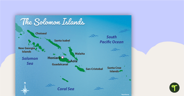
Familiarise your students with Australia’s neighbouring countries with this detailed map of The Solomon Islands.
Australia and Its Neighbours: The Solomon Islands
While the continent of Australia is also a single country, it is surrounded by many island nations that we consider to be our neighbours. One such nation is The Solomon Islands.
The Solom Islands are located to the north-east of Australia in the South Pacific Ocean. They consists of six major islands, the largest being Guadalcanal. The archipelago also consist of over 900 smaller islands.
Multiple Applications of This Map of The Solomon Islands
This colourful classroom map shows some of the major islands and cities of The Solomon Islands. It is the perfect resource to accompany your Geography lessons on Australia and its neighbouring countries. You may wish to use this poster in the following ways:
- Print the poster on A3 paper and display it in your classroom as a reminder of the geographical features of The Solomon Islands.
- As you teach your students about Australia’s neighbouring countries, provide students with a smaller version of the poster to paste into their workbooks.
- Add this poster to a classroom display about Australia and its surrounding countries. Encourage students to add facts about The Solomon Islands around the poster.
Download, Print, Teach!
This resource downloads as a full-colour PDF and can be accessed via the dropdown menu above.


Solomon Sea is misspelled. Also, with this and other maps in this series, I think you need to review your use of visuals. E.g. - what is the building near Honiara supposed to represent? Unless it adds a talking point for students that is based on fact, I don't see the point. Having said that - thank you for creating teaching resources for Oceania, there are too few out there.
Hi Deryn, Thank you for your comment. We'll update the resource and let you know when it is ready.