
Get a printable & digital blank map of Europe for your continent and oceans lessons!
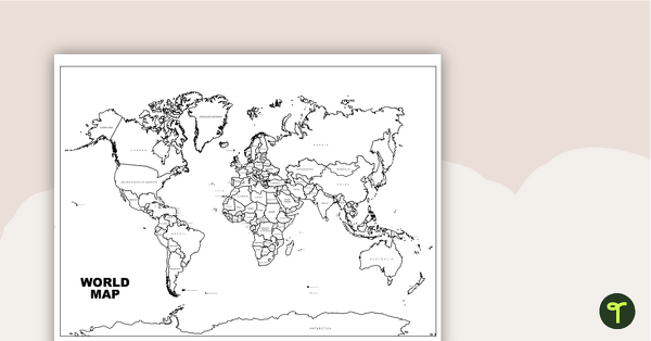
A Printable Blank Map of Europe for Labeling
Are you exploring the vast continent of Europe with your students? Download the one map that covers all your geography activities — available as a printable PDF or a digital Google Slides template.
You can use the unlabeled, black-and-white map of Europe to help students explore the natural and human features of this diverse continent.
Multiple Uses for This Map of Europe Worksheet
Looking for ways to use your new map of Europe? Try these from our teacher team:
Label key locations as a whole-class activity
This versatile Europe map can be projected onto your interactive whiteboard for a paperless lesson or class review session. Have students take turns labeling key locations on the blank map using a whiteboard marker.
Create a progressive, comprehensive map of Europe
At the beginning of a unit of work on Europe, provide students with their own printed copy of the blank Europe map. During the course of your unit of work, have students add more and more detail to their maps. They could add features such as:
- Capital cities such as Paris, France and Sofia, Bulgaria
- Rivers such as the Rhine, Volga and the Seine
- Mountains such as the Alps and the Pyrenees
What Are the Countries in Europe?
Our teacher team left this map blank so it would be more easily adapted for your lesson planning, but don’t worry! The more than 40 countries in Europe are accounted for with their borders intact. Here’s a quick look at the list of countries in Europe, listed in alphabetical order, to use as a quick reference:
- Albania
- Andorra
- Austria
- Belarus
- Belgium
- Bosnia and Herzegovina
- Bulgaria
- Croatia
- Cyprus
- Czech Republic
- Denmark
- Estonia
- Finland
- France
- Germany
- Greece
- Hungary
- Iceland
- Ireland
- Italy
- Kosovo
- Latvia
- Liechtenstein
- Lithuania
- Luxembourg
- Malta
- Moldova
- Monaco
- Montenegro
- Netherlands
- North Macedonia
- Norway
- Poland
- Portugal
- Romania
- Russia (part of Russia is in Europe — download a map of Asia for the other part!)
- San Marino
- Serbia
- Slovakia
- Slovenia
- Spain
- Sweden
- Switzerland
- Ukraine
- United Kingdom
- Vatican City
Tips for Scaffolding and Extention
In any classroom, there is a multitude of learning needs that must be catered for in every single lesson! We’re here to help with some tips and tricks that may help you differentiate the application of this teaching resource:
- Scaffolding Tips: Some students may find the precise nature of mapping difficult… and that’s okay! Support them by allowing them to access an atlas or digital mapping tool while completing the activity. Completing mapping tasks in a small group can also make students feel more supported and confident in their learning.
- Extension Tips: For those students who are confident in their geographical skills, why not fine-tune their mapping skills by having them add additional map features to their map? For example, students could apply a color-coding system for various locations or features, then add these to a legend or key.
Download Your Digital or Printable Map
Use the dropdown arrow next to the Download button to access the easy-print PDF version or the editable Google Slides version of this resource.
More Continent Maps for Teachers
Looking for maps of the other continents? Check out these printable and digital options:
[resource:4943463] [resource:2666378] [resource:2666926]


0 Comments
Write a review to help other teachers and parents like yourself. If you'd like to request a change to this resource, or report an error, select the corresponding tab above.